

Executive Summary
Urban supply chain strains and recurring global civil unrest highlight the strategic security advantages of low-density rural locations, including reduced risk of resource shortages, a lower likelihood of civil disturbances, and enhanced physical security for families building resilient estates. In 2026, zones exceeding 50 people per square mile carry elevated risks of resource competition, logistical failure, and secondary instability. Calculated Risk Advisors advises targeting counties and parcels that remain consistently below this density threshold, supported by rigorous zoning analysis, natural isolation buffers, and compounds designed for concealment and complete self-sufficiency.
Advanced fallout modeling, incorporating jet-stream behavior, prevailing winds, and historical nuclear-test data, further narrows selections to sites where natural topography provides meaningful deflection of potential contamination. Families engaging in the next 60 days secure meaningful optionality for long-term autonomy and multi-generational legacy protection as global geopolitical conditions decline rapidly.
Urban Supply Chain Strain and Civil Unrest Reinforce Rural Advantages
Major North American metropolitan areas continue to experience chronic supply-chain fragility. Port delays, rail disruptions, and just-in-time systems routinely convert minor events into extended shortages of fuel, food, and medical supplies. When combined with civil unrest, these failures can rapidly compromise safety and access even in affluent districts. For high-net-worth families, proximity to dense population centers has shifted from an advantage to a liability. Rural areas with fewer than 50 people per square mile have demonstrably lower incident rates during periods of stress, reduced resource competition, and greater operational continuity. Your estate gains lasting independence through this geographic discipline.
High-Density Urban Hotspots: Illustrative Vulnerabilities in 2026
The following major centers illustrate the pattern:
- Miami-Dade and Fort Lauderdale, Florida: Core densities above 1,200 per square mile, exacerbated by seasonal surges. Port disruptions and hurricane-related shortages frequently affect even wealthy areas, while migration-driven unrest has elevated property crime and security costs.
- New York City and Chicago: Core densities exceeding 10,000 per square mile. Supply chokepoints and 2025 unrest episodes showed how quickly upscale neighborhoods can face spillover effects and mobility restrictions.
- Los Angeles: Densities over 8,000 per square mile, with port/freeway dependencies and recurring grid strain amplifying wildfire and power risks.
- Dallas: Core areas approaching 4,000 per square mile, where logistics hubs become flashpoints during shortages.
Similar dynamics appear in Atlanta, Houston, and Philadelphia. In all cases, families encounter intensified resource competition, higher security demands, regulatory pressure, and diminished privacy.
The Density Threshold: Why Below 50 People per Square Mile Matters
This benchmark marks the point at which population pressure materially elevates vulnerability. Below it, genuine self-reliance becomes feasible: neighbors are miles apart, sightlines are defensible, and unintended convergence during crises is minimized. The threshold also correlates with more favorable insurance profiles and permits autonomous infrastructure.
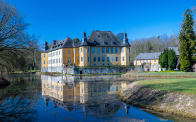
Comparative Analysis of Exemplary Low-Density Rural Counties
The counties listed meet strict safety criteria, ensuring families feel confident in their estate security and resilience planning.
- Beaverhead County, Montana (~2.4/sq mi): Abundant groundwater, fertile valleys, and topographic shielding that directs potential contamination eastward or northward. Large private ranches owned by ultra-high-net-worth individuals set a precedent for seamless integration.
- Lemhi County, Idaho (~1.7/sq mi): Perennial rivers, favorable microclimates, and stable low-intensity zoning. HNWI presence is well-documented through conservation and ranch holdings.
- Sublette County, Wyoming (~4.1/sq mi): Deep aquifers, open-range isolation, and strong zoning protections. Legacy estates and land trusts are common among affluent owners.
- Harding County, South Dakota (~0.5/sq mi): Exceptional deep-soil productivity, redundant transport without urban adjacency, and agricultural zoning that prevents density creep. The county lies outside dominant fallout corridors under prevailing westerly flows.
These counties were selected because they satisfy all core safe-zone criteria while demonstrating proven HNWI/UHNWI occupancy—attributes that differentiate them from purely remote, resource-poor jurisdictions. Side-by-side matrix comparisons prepared by Calculated Risk Advisors confirm their superiority.
Zoning and Isolation Buffers: Legal and Practical Considerations
Agricultural and low-intensity zoning in these counties typically enforces generous minimum lot sizes and subdivision restrictions, creating de facto isolation. Natural features—ridgelines, rivers, and public lands—create durable physical and visual buffers. Calculated Risk Advisors conducts comprehensive title and land-use reviews to identify emerging threats to isolation and, when advantageous, recommends conservation easements or phased adjacent acquisitions.
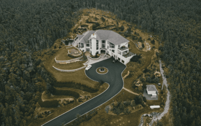
Designing Concealed and Self-Sufficient Compounds
Thoughtful design and zoning create estates that blend into the landscape, fostering confidence in their security and self-sufficiency.
International Low-Density Haven Comparison: Cautionary Lessons and Select Opportunities
While North American selections remain the cornerstone for most U.S.-centric families, a balanced global assessment is prudent for portfolio diversification. Several frequently discussed international jurisdictions offer superficial rural density advantages but carry structural risks that undermine long-term personal freedoms and operational autonomy for HNWI/UHNWI clients.
Compounding these policy risks is the intensifying geopolitical climate of 2026. Ongoing U.S. military engagements have significantly deteriorated America’s global image. In many international destinations, U.S. citizens are increasingly viewed not as neutral high-net-worth individuals but as symbols of a nation deeply entangled in controversial conflicts. This perception has translated into heightened cultural friction, social ostracism, business discrimination, and in certain regions, elevated risks of ethnic targeting or criminal opportunism—including concerns around children’s safety and potential kidnapping threats for visibly affluent American families. For HNWI and UHNWI clients seeking true long-term legacy protection, these intangible yet very real headwinds make foreign relocation far riskier than it appears on paper and strongly reinforce the advantages of carefully selected North American low-density zones.
Uruguay, Argentina, Chile, Panama, and New Zealand each maintain pockets of low-density countryside. However, recent policy trajectories introduce unacceptable exposure through expanding digital-ID systems, CBDC pilots, and energy/travel controls that erode personal sovereignty.
In contrast, Switzerland remains a standout exception. Rural cantons such as Graubünden and Valais maintain very low population density while providing robust constitutional protections for privacy, property rights, and economic freedom. The voluntary e-ID rollout remains optional and user-controlled, with no centralized data mandates, no CBDC experimentation, strict banking secrecy traditions, and unrestricted mobility.
Paraguay presents a pragmatic complementary opportunity for families prioritizing cost efficiency and territorial taxation. Vast rural departments such as San Pedro and Caaguazú register densities well under 20 people per square mile, offering expansive, low-signature landscapes suitable for large-scale estates. Foreigners enjoy equal property ownership rights, with no taxes on foreign-sourced income. Residency is accessible and relatively low-cost. Positives include exceptionally low living and operational costs, stable governance, and minimal restrictions on energy or domestic travel. However, practical HNWI realities require candid assessment: banking access for high-value international transfers remains more limited than in Switzerland, judicial predictability benefits from professional structuring, and quality healthcare for complex needs often requires regional or U.S. travel. The 2026 crypto-asset reporting rules (Resolution 47/26) mandate disclosure of transactions exceeding $5,000 annually, adding another layer of compliance to wealth structuring. While no full CBDC or mandatory digital ID exists, the direction of travel suggests increased transparency requirements. Paraguay functions best as a diversified secondary holding rather than a primary residence for most ultra-high-net-worth families (based on currently available open-source and commercial intelligence).
Actionable Steps: Securing Your Low-Density Advantage in Q2 2026
- Commission a confidential density-risk assessment covering target zones (30-day turnaround).
- Short-list parcels meeting density and isolation criteria.
- Review zoning and structure acquisitions through appropriate LLC entities
- Begin master-planning for concealed, self-sufficient features during due diligence.
- Secure adjacent land options for future expansion.
Final Thought
In an era defined by urban fragility and shifting global perceptions of American wealth, the disciplined pursuit of sustained low-density locations within North America, reinforced by rigorous fallout modeling, zoning protection, and purpose-built design, represents one of the most defensible strategies available for preserving autonomy and legacy. International alternatives, while occasionally appealing on paper, must be weighed against both policy erosion and the real-world challenges now facing American families abroad. This is calculated positioning at its core. Families who complete this planning phase now will hold resilient options long into the future.
If you are evaluating sites or refining a short list, Calculated Risk Advisors is prepared to deliver a comprehensive Low-Density Site Optimization Report tailored to your family’s objectives. The engagement typically concludes with an actionable roadmap within 30 days.
Contact us today to schedule a private strategy session. The window for securing premium low-density platforms narrows as awareness spreads.
Stay calculated. Stay ahead.
Next briefing: International vs Domestic Safe Havens for Family Compounds
Disclaimer for this brief: This intelligence brief is for informational purposes only and represents analytical opinions based on public sources and hypothetical scenarios. It does not constitute financial, legal, or investment advice. You can consult qualified professionals for personalized guidance. All future events described are speculative and not predictions. References to the Great Reset’s goals reflect common criticisms and are not official WEF positions.
© 2026 Calculated Risk Advisors. All rights reserved.

0 Comments